еще ответ от крутых перцев...
Thanks for your email -
I am more than happy to help -
I have rafted in the Altai and i know you have some fantastic rivers!
I am going to suggest you do the both the Cotahuasi and the Colca Canyons --
May can be a little high so i do suggest early June!
The Apurimac is also a beutiful river but it can be crowded with commercial companies - If you want to go extreme on the Apurimac then you have to run the section called the Abyss - this is best when water is low in August or September or even October - -
If you want i can organize someone to help with all the logistics -
Warmest regards,
Marc Goddard
Bio Bio Expeditions
marc (собака) bbxrafting.com
P.O Box 2028
Truckee, CA 96160
1 800 246 7238 (toll free)
530 582 6865 (office)
530 913 3754 (cell)
Kat2
Надо непременно встряхивать себя физически, чтобы быть здоровым нравственно (Л.Н.Толстой)
AMERIKANA
Модераторы: whirl, ravil, ww, kat2
Re: AMERIKANA
![]() ravil » Сб янв 30, 2010 6:50 pm
ravil » Сб янв 30, 2010 6:50 pm
- ravil
- Сообщений: 267
- Зарегистрирован: Сб апр 07, 2007 4:49 pm
Re: AMERIKANA
![]() ravil » Пн фев 01, 2010 11:44 pm
ravil » Пн фев 01, 2010 11:44 pm
еще ответ от одних:
"Apurimac in May is starting to drop from the rainy season so is big to
medium level.
There are two section to Raft we recommend Nahui to Hualpacacha 4 days -
mainly class 3 with the odd 4 and 5, and the commercial section Puente
Hualpachaca to Puente Cunyoc Class 4 - 5 again 3 - 4 days
Cotahuasi is Medium flows in May - the best level to attempt this river.
Allow 1 day drive from Arequipa - 1 2 days hike to river start and 6 - 8
days on the river.
Let us knoew if we can assist with logistics."
Kind Regards
Paul Cripps
Amazonas Explorer SA
sales@amazonas-explorer.com
www.amazonas-explorer.com
UK phone 00 44 1874 658125 00 44 1874 658125
- ravil
- Сообщений: 267
- Зарегистрирован: Сб апр 07, 2007 4:49 pm
Re: AMERIKANA
![]() ravil » Вт фев 02, 2010 12:00 am
ravil » Вт фев 02, 2010 12:00 am
А вот этот запрос я отправил в выходные kurt casey с peruwhitewater. Жду ответа...
Very Thank you, Kurt, for answer!
I sent you map from gmail.com (mwru750) yesterday. Please, look at it and remark on it the sections of Apurimac (three sections, their starts and finishes)
And I have more questions:
- What river is more interesting: Cotahuasi or Colca (Lunar Canyon)?
- Is possibly start from Cotahuasi village and then portage Sipia fall? Or we need take the mules and go below Sipia fall?
- What section is interesting on Apurimac: "Black Canyon" or "Commerical section"?
- What length of second and third section of Apurimac?
- Where is the end of Acobamba Abyss section?
- You wrote: "I would not do this section until June or after" (about Abyss). I didn`t know: June is the better time for it?"
- How would you the travelling trip with extrem rafting and showplace for 16-18 days (for us)
I`m waiting for You answer.
Ravil
- ravil
- Сообщений: 267
- Зарегистрирован: Сб апр 07, 2007 4:49 pm
Re: AMERIKANA
![]() ravil » Вт фев 02, 2010 2:39 pm
ravil » Вт фев 02, 2010 2:39 pm
Ответ от русскоговорящего сотрудника перуанской турфирмы:
" - сколько ехать из Лимы до нац.парка Паракас (и до Наски) [
i]s limu do paracasa 3.5 chasa, do nazci ot paracasa echio 3 chasa[/i]
- стоит ли Паракас посещения? Возможно ли уложить посещение Паракаса и
облет Наски в один полный день?
da eto mozhno sdelat, vuezzhayut s limu v 4.30 utra, v Paracase b 8 utra posadca na lodku y 2.5 chasa
excursii, pributie v 10.30, 30 minut na chay, v 11 vuexali po napravleniyu v Nazcu, v 14.30 v Nazce, poletali nad liniyami nazca, 30 minut poliot esli v 2 fruppu to okolo 1.5 chasa. potom na obed yly uzhin
- сколько ехать от Наски до Арекипы
s Nazci do arequipu exat 6 chasov eto mozhno sdelat yly na otdelnom avtobuse tolko dlia vas? luchche
conechno exat dniom, yly na mezhdugorodnem avtobuse spalnom, confortabelnom v nochnoe vremia s 23 chsov do 5 utra
- сколько ехать от Арекипы доначала сплава на Котахуаси или на Колке?
exat okolo 5 chasov
- сколько примерно составит переезд от Арекипы до Пуно (Титикака) и до
Куско?
pereezd s arequipu do Puno zanimaet okolo 5 cjasov, y s Puno do Cusko 7 chasov
- экскурсия в Мачу-Пикчу занимает один день или там приходится заночевать?
zanimaet polnuy den vuezzhaet poezd v 7 utra y priezzhaet obratno v 8 vechera
- сколько займет переезд после Апуримака (например от дороги на Абанкай) до Лимы?
24 chasa
- ravil
- Сообщений: 267
- Зарегистрирован: Сб апр 07, 2007 4:49 pm
Re: AMERIKANA
![]() zhyk » Вт фев 02, 2010 9:40 pm
zhyk » Вт фев 02, 2010 9:40 pm
на вв ролик свежий кинули с Перу. Апуримак - МачуПикчу
http://ww-video.ru/mediadetails.php?key ... a5c58f1d2e
могу чела через личку распросить подробности, Равиль сформулируй вопросы.
http://ww-video.ru/mediadetails.php?key ... a5c58f1d2e
могу чела через личку распросить подробности, Равиль сформулируй вопросы.
- zhyk
- Сообщений: 296
- Зарегистрирован: Ср фев 18, 2009 6:44 pm
Re: AMERIKANA
![]() whirl » Ср фев 03, 2010 11:41 pm
whirl » Ср фев 03, 2010 11:41 pm
Кино про Мачу-пикчу не плохое, но вот апуримак вообще не впечатлил....
Должны же быть трудности
-

whirl - ведущий к-двоишник
- Сообщений: 567
- Зарегистрирован: Пн мар 26, 2007 6:40 am
Re: AMERIKANA
![]() ravil » Чт фев 04, 2010 12:58 am
ravil » Чт фев 04, 2010 12:58 am
Я думаю, что они были поздно летом, явно по малой воде.
Серега, спроси у них в какое они время были, какой кусок реки прошли (прямо пусть к карте привяжется, она есть на этом сайте), Кинкулькин - известный чел, может он вообще что посоветует или расскажет.
На самом деле я наверно найду его номер и свяжусь с ним лично...
Серега, спроси у них в какое они время были, какой кусок реки прошли (прямо пусть к карте привяжется, она есть на этом сайте), Кинкулькин - известный чел, может он вообще что посоветует или расскажет.
На самом деле я наверно найду его номер и свяжусь с ним лично...
- ravil
- Сообщений: 267
- Зарегистрирован: Сб апр 07, 2007 4:49 pm
Re: AMERIKANA
![]() ravil » Чт фев 04, 2010 1:01 am
ravil » Чт фев 04, 2010 1:01 am
Ravil I try to answer your questions below.
1. What river is more interesting: Cotahuasi or Colca (Lunar Canyon)?
Both rivers are very interesting. I would suggest you do both. The Lunar canyon is not so long. Maybe 40 km total. I have done it in one day but also did ot very slowly and made it 10 days long with lots of camping and hiking. I think 3 days, 4 maximum for lunar canyon. The "Upper Colca" from cabanaconde is 3 more days but only good in kayak. It is too small for rafts with difficult portages.
- Is possibly start from Cotahuasi village and then portage Sipia fall? Or we need take the mules and go below Sipia fall?
Yes you can even start above Cotahuasi. A new road goes up Cotahausi so you can follow the road and start where you like and see the river. You can perhaps another 1-2 days above Cotahuasi town. The river never touches the town. It is actually in deep canyon called Aimana gorge when it passes below the town. There is a trail to the river with a swinging bridge over the canyon. Just below the bridge there is a difficult portage where you have to carry all equipment several hundred meters out of the canyon then walk about 1 KM and find a trail (very hard to find) that leads back down to the river in a very steep canyon...I would not want to do this with a raft or be in a raft in the Aimana gorge as it is small and very steep. Where the Aimana gorge opens up it meets the road coming down from Cotahuasi so it is easy to put in here and it is still several km above SIPIA. This section down to Sipia falls is very steep. Maybe 50 meter per kilometer average and would be very EXTREME in raft but it is possible and the trail is always close to river if there were problems.
The portage around SIPIA takes 4-5 hours per my memory. You can put -in below SIPIA below a small group of houses and then raft FLATWATER canyon that has very steep section at 57 meters per kilometer. Rafts usually continue portage and start below town of Velinga. From here is probably 60 km to Iquipe where you can take out. If you want you can continue all the way to the ocean or to where Pan AMerican highway crosses river right near coast. It is 2 more days which are sometimes hard because of wind and or slow water.
- What section is interesting on Apurimac: "Black Canyon" or "Commerical section"?
Both sections are interesting. You should do both if you do Apurimac and if you want very extreme continue to the "Acombamba Abyss" dowstream.
- What length of second and third section of Apurimac? I would guess "commerical section is 50 KM and Acombamba Abyss is more than 100km if you go all the way to San Francisco. You can make Abyss section shorter by getting out when canyon opens up at a bridge. It is very hard to find vehicles at this bridge so you need to carefully arrange transportation. See descriptions of each section in website www.peruwhitewater.com
- Where is the end of Acobamba Abyss section?
you have two options for takeout
I got out after 4 very diffiucly days at a bridge where diffiuclt whitewater finishes. It is just below where Rio Pachachaca comes into APurimac and just above where Rio Pampas comes in. From the bridge you go to Adahuaylas then Abancay then back to Cuzco.
My wife did ABYSS in a raft and it took 10 days. She continued into jungle town of San Francisco then to Ayacucho then Abancay then back to Cuzco.
- You wrote: "I would not do this section until June or after" (about Abyss). I didn`t know: June is the better time for it?"
Yes you can do in June, July, August, september and first half of October.
Before June the Abyss has too much water and in late October the rains start and river can rise very quickly. Usually November to end of April it is much too big. When went end of October and had 3 days of rain. The river grew over five times the size we stared on and was diffiuclt camping, brown water that was hard to filter and slippery rocks to portage.
PS the google map was not very good for showing the river. I am going to try to fotocopy another map and draw on it approximately where each section is. right now we rented our house to other people so are living in tents for 2 weeks. I will not be able to do anything for about 2 weeks.
- ravil
- Сообщений: 267
- Зарегистрирован: Сб апр 07, 2007 4:49 pm
Re: AMERIKANA
![]() whirl » Чт фев 04, 2010 9:21 pm
whirl » Чт фев 04, 2010 9:21 pm
Равиль, а это за участок на катуаси с перепадом 50 метров на километр?
Вопрос, это падение непрерывное. Или двумя водопадами по 25 метров.... Этим каякерам ведь по барабану, пройдут и не заметят...
Вопрос, это падение непрерывное. Или двумя водопадами по 25 метров.... Этим каякерам ведь по барабану, пройдут и не заметят...
Должны же быть трудности
-
whirl - ведущий к-двоишник
- Сообщений: 567
- Зарегистрирован: Пн мар 26, 2007 6:40 am
Re: AMERIKANA
![]() ravil » Пт фев 05, 2010 12:55 am
ravil » Пт фев 05, 2010 12:55 am
http://www.bluedome.co.uk/WaterSports/wateperu.html
- несколько фактов о реках Перу.
- несколько фактов о реках Перу.
- ravil
- Сообщений: 267
- Зарегистрирован: Сб апр 07, 2007 4:49 pm
Re: AMERIKANA
![]() Vovan » Пт фев 05, 2010 12:13 pm
Vovan » Пт фев 05, 2010 12:13 pm

- Vovan
- Сообщений: 11
- Зарегистрирован: Пн апр 27, 2009 12:01 pm
Re: AMERIKANA
![]() whirl » Пт фев 05, 2010 11:19 pm
whirl » Пт фев 05, 2010 11:19 pm
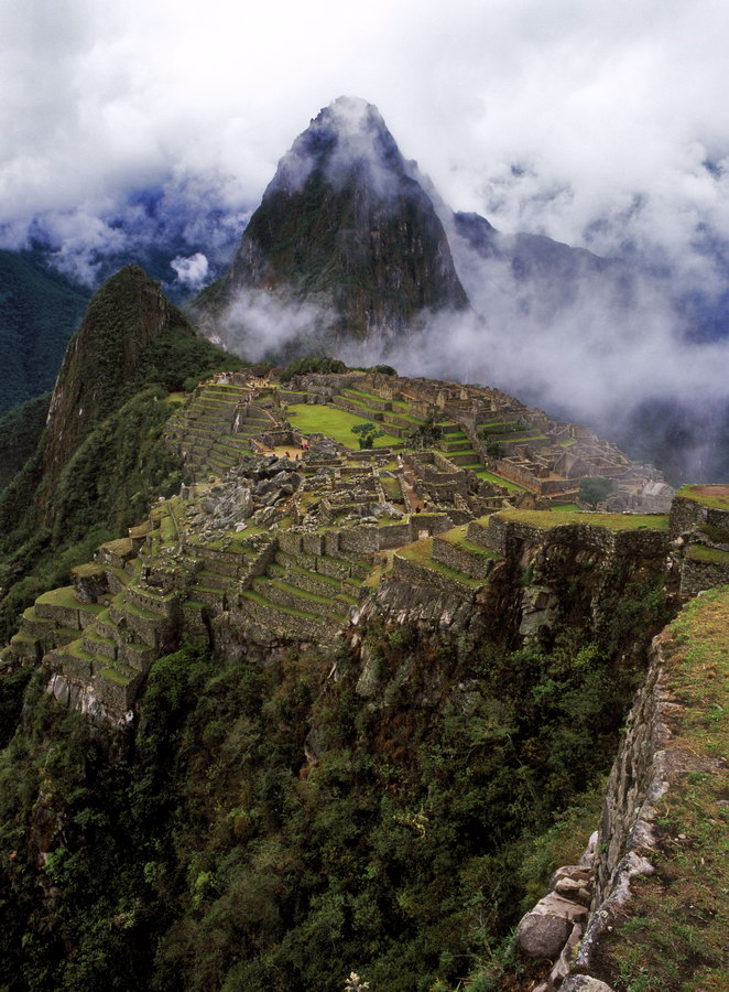
Какая замечательная речка промыла дорогу на Мачу-Пикчу. Может нам по ней идти?
а что, падение приятное:-)
а что, падение приятное:-)
Должны же быть трудности
-
whirl - ведущий к-двоишник
- Сообщений: 567
- Зарегистрирован: Пн мар 26, 2007 6:40 am
Re: AMERIKANA
![]() whirl » Пт фев 05, 2010 11:41 pm
whirl » Пт фев 05, 2010 11:41 pm
http://mikluha-maklai.livejournal.com/53753.html можно посмотреть фотографии с озера Титикака...
Я лично не проникся.....И остаюсь при своем мнении, что туда стоит ехать ради галочки -а это считаю бессмысленным.
Я лично не проникся.....И остаюсь при своем мнении, что туда стоит ехать ради галочки -а это считаю бессмысленным.
Должны же быть трудности
-
whirl - ведущий к-двоишник
- Сообщений: 567
- Зарегистрирован: Пн мар 26, 2007 6:40 am
Re: AMERIKANA
![]() zavkhoz » Сб фев 06, 2010 2:38 pm
zavkhoz » Сб фев 06, 2010 2:38 pm
whirl писал(а):http://mikluha-maklai.livejournal.com/53753.html можно посмотреть фотографии с озера Титикака...
Я лично не проникся.....И остаюсь при своем мнении, что туда стоит ехать ради галочки -а это считаю бессмысленным.
Спасибо за ссылку. Очень интересно!
Плавучие острова, земля под ногами буквально "горит"-гниет.
Любопытно, как бы мы осваивали свои дома, если бы знали, что через 30 лет
они уйдут под воду?
Расскрою тайну: весь поход в Перу - для галочки.
-

zavkhoz - Завхоз
- Сообщений: 1038
- Зарегистрирован: Сб мар 17, 2007 11:30 pm
Вернуться в походы: реки, горы
Кто сейчас на конференции
Сейчас этот форум просматривают: нет зарегистрированных пользователей и гости: 5